
A Historic El Niño Is Building: What Could It Mean for U.S. Agriculture?
Authored by the American Prime Sustainable Solutions team, with insights and technical feedback from Dr. Jeff Basara
One of the strongest El Niño events in decades is developing in the Pacific — and its timing and associated impacts during the fall and winter will be particularly important for U.S. agriculture throughout the remainder of 2026 and into 2027. The latest NOAA ENSO update, released August 13, confirms that El Niño has strengthened rapidly over the past month with sea-surface temperature anomalies that exceed +2°C in the eastern equatorial Pacific. Further, both oceanic and atmospheric indicators show a strengthening, fully coupled El Niño pattern with a greater than 90% chance of a very strong El Niño during fall and winter of 2026–27. For the October–December period, NOAA estimates a near 70% chance that the event could reach historic strength, exceeding previous El Niño events dating observed since 1950.
NOAA’s newly released August 20 seasonal outlook notes that El Niño is expected to become an increasingly dominant factor from late fall through winter. Historically, El Niño tends to shift the Pacific jet stream southward, increasing the likelihood of wetter and cooler conditions across parts of the southern United States while favoring warmer and drier winters farther north. But even during very strong El Niño events, these patterns are not guaranteed — and agricultural impacts can vary significantly by region.
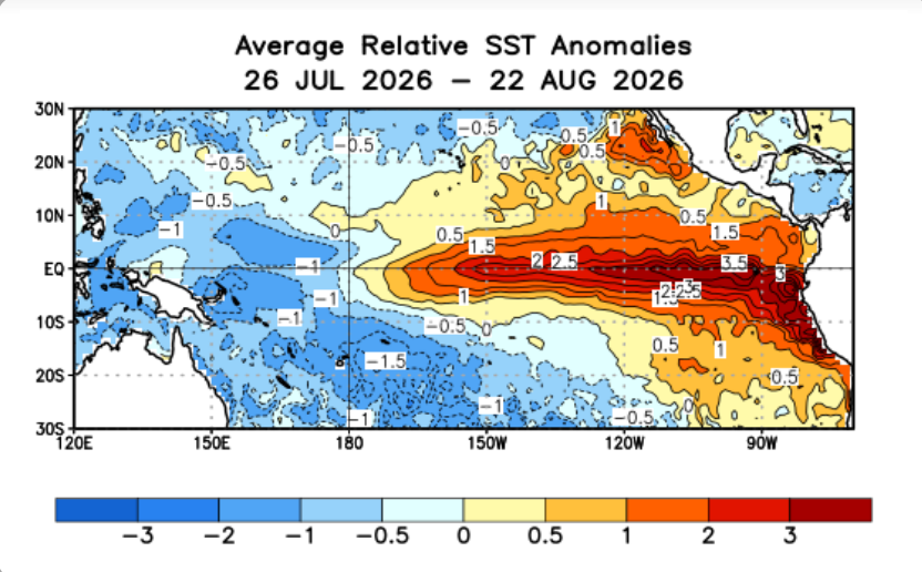
Figure 1. Average relative sea surface temperature (SST) anomalies across the tropical Pacific during the previous four weeks. Source: NOAA Climate Prediction Center (CPC) / NCEI / NCEP; NOAA OISST v2.1.
What Could El Niño Mean for U.S. Crops?
For U.S. agriculture, the question is quickly shifting from how strong El Niño will become to where and when its impacts will occur. The first intersection comes during the final stages of the 2026 corn and soybean season. USDA’s August 17 Crop Progress report showed U.S. corn conditions slipping to 60% good-to-excellent, down from 61% the previous week and well below the 71% reported at the same point last year. With much of the crop already moving toward maturity, however, the role of weather is gradually shifting from determining yield potential toward determining harvest conditions, field access, drying and crop quality. Soybeans remain somewhat more exposed to late-season weather because August and early September moisture can still influence pod development and seed fill. The latest NOAA outlook adds another layer of uncertainty. For September through November, NOAA now favors above-normal precipitation from the Southwest into the central and southern High Plains, while portions of the Great Lakes and Northeast tilt toward below-normal precipitation.
At the same time, much of the western and central United States is favored to remain warmer than normal during the fall. That does not necessarily translate into a uniformly difficult harvest as El Niño is a large-scale climate pattern, not a field-level forecast. But it does increase the importance of staying vigilant to rainfall and temperature anomalies that overlap with individual production regions as corn and soybean harvest progresses. For farmers, the bigger El Niño story may actually begin after the 2026 crop leaves the field. Fall precipitation will start determining soil-moisture reserves going into winter. Those conditions, combined with winter rainfall and snowfall, will influence the starting point for the 2027 crop season. And one major U.S. crop will begin that new production cycle much sooner.
Winter Wheat: The First Major Crop to Watch
Winter wheat could become the first major U.S. crop to experience El Niño throughout an entire production cycle. Planting will begin across the Great Plains this fall just as El Niño is expected to strengthen and its influence on North American weather becomes more pronounced. That makes Kansas, Oklahoma and Texas particularly important regions to watch. The Southern and Central Plains have already dealt with significant heat and moisture stress during the growing season of 2026 due to ongoing drought conditions. For producers preparing to seed winter wheat, the key question is whether fall precipitation can replenish topsoil moisture sufficiently for planting, germination and establishment. In this case, El Niño could actually become an opportunity rather than simply a threat. NOAA’s August 20 outlook favors above-normal fall precipitation extending into the central and southern High Plains. If that pattern materializes, additional moisture could improve planting and establishment conditions across parts of winter wheat country.
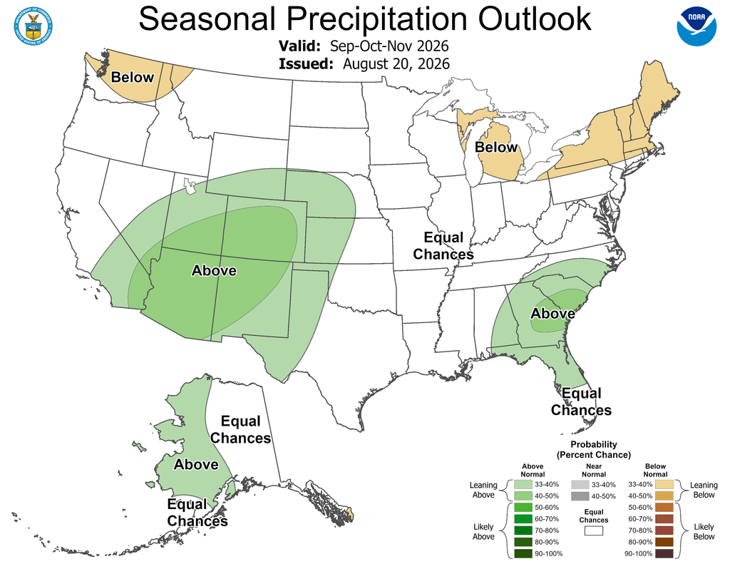
Figure 2. NOAA seasonal precipitation outlook for September–November 2026 (issued August 20, 2026). Source: NOAA Climate Prediction Center (CPC) / National Weather Service / NCEP
But timing and distribution will matter. Too little rain may leave producers planting into dry soil; well-timed precipitation could substantially improve establishment; while excessive rainfall could delay fieldwork in localized areas. This is why a strong El Niño cannot simply be labeled “good” or “bad” for agriculture as overall impacts depend on when and where the precipitation falls and the corresponding crop stage at the time of occurrence.
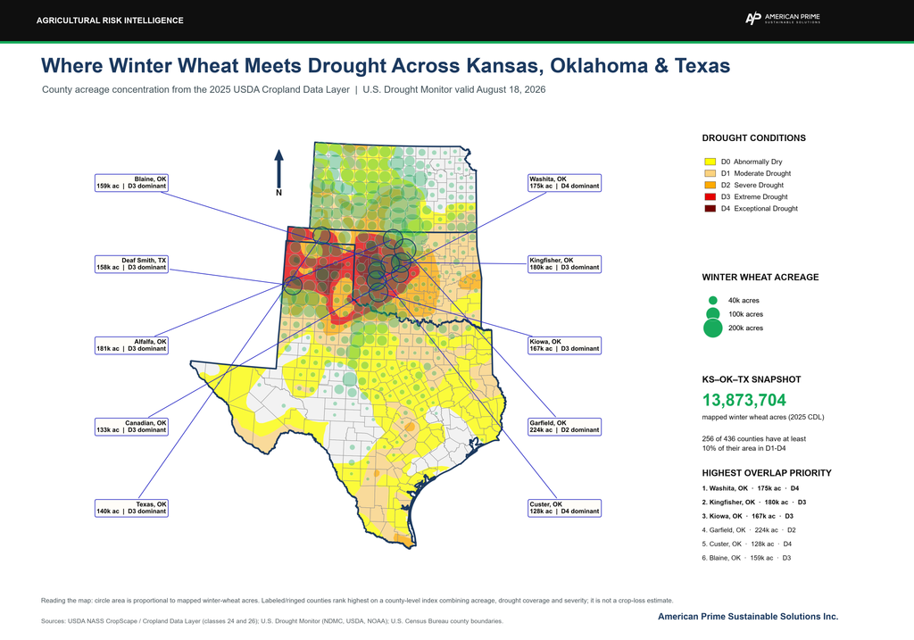
U.S. Agriculture Through Fall and Winter: Building the Starting Point for 2027
Beyond winter wheat, perhaps the most consequential agricultural impact of El Niño will be what happens to soil moisture between the 2026 harvest and spring planting in 2027. A wetter fall and winter across drought-affected areas of the southern and central Plains could rebuild soil-moisture reserves, improve pasture and rangeland conditions and provide a stronger starting point for spring crops. The agricultural impact of this El Niño may therefore ultimately be measured less by what happens during the final weeks of the 2026 crop season and more by the conditions it creates for 2027. By late winter, several agricultural questions will become increasingly important:
- Corn and soybeans: Will the Midwest enter spring 2027 with adequate soil-moisture reserves, or could excessive precipitation create fieldwork and planting delays?
- Spring wheat: How will winter precipitation and snowpack affect soil moisture across the Northern Plains?
- Cotton and sorghum: Could improved winter moisture help areas of Texas, Oklahoma and Kansas that experienced significant drought and crop stress in 2026?
- Pasture and livestock: Will increased southern precipitation improve pasture and rangeland conditions ahead of the 2027 grazing season?
South America: A Global Market Factor
El Niño’s importance to U.S. producers does not stop at the U.S. border. As American farmers move through harvest and winter, producers in Brazil and Argentina will be planting and developing their 2026–27 soybean and corn crops. Changes in precipitation associated with El Niño could therefore influence global production at exactly the time U.S. markets begin assessing 2027 supply prospects.
For U.S. producers, the connection is ultimately economic and quite sufficient. A major change in South American corn or soybean production could significally affect global supplies, export competition and commodity prices — meaning that El Niño’s impact on a U.S. farmers may come both from the weather conditions in their own field and from weather thousands of miles away.
What to Watch Next
There is still considerable uncertainty around exactly how this El Niño will translate into weather at the farm level. NOAA cautions that even with an event of this magnitude, typical El Niño impacts become more likely, not guaranteed. Between September and winter, the most important signals to monitor will include the continued strength and expected peak of El Niño, NOAA precipitation and temperature outlooks, changes in the U.S. Drought Monitor, soil-moisture conditions across the Plains and Midwest, corn and soybean harvest progress, winter wheat planting and establishment, and South American planting conditions. The next major NOAA ENSO Diagnostic Discussion is scheduled for September 10, providing another opportunity to assess whether the event remains on its potentially historic trajectory. For producers, this also highlights the growing value of connecting large-scale climate forecasts with conditions on individual farms. El Niño increases the probability of certain weather patterns that may occur. However, agricultural outcomes ultimately depend on what happens in a particular field, at a particular crop stage, at a particular time.
Tools such as American Prime Intelligence Platform, which combines satellite-based field monitoring with weather information and other field-level insights, can help producers track those changes as conditions evolve — identifying emerging crop stress and supporting more informed decisions throughout the season. As one of the potentially strongest El Niño events in decades continues to build in intensity and impacts, the challenge for agriculture will not simply be predicting the weather. Rather, it will be how weather impacts translate to the farm field.
Sources:
Climate Prediction Center: ENSO Diagnostic Discussion
Climate Prediction Center – Seasonal Outlook
El Niño in the Northwest: What Can We Expect? | USDA Climate HubsUSDA – National Agricultural Statistics Service – Charts and Maps – 2025 Crop Progress and Conditions